Dead Horse Point, near Moab, Utah, is a high plateau peninsula connected to the main plateau by a narrow neck of land. It is part of Dead Horse Point State Park and has spectacular views of the Colorado River, Canyonlands National Park, La Sal Mountains, and other scenic features.
According to legend, the point, with it’s 30 yard wide neck, was used as a natural corral by 19th century cowboys. Apparently, at one time, the corral was abandoned, gate left open, with unwanted cull horses still inside. Not all of the horses left the point, dying of thirst in view of the Colorado River 2000 feet below.
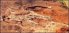
 A more prosaic explanation is that Dead Horse Point was named by early Mormon Pioneers for a rock formation at the base of the plateau that looks like a dead white horse laying on its side (photo on left). In this explanation, the legend of the dead horses in the corral was created by a Moab elementary school student in the early 20th century for a “chamber-of-commerce” type contest for a story to lure tourists.
Selected Information Resources:
Dead Horse Point State Park

